In the first 2026 edition of our OpenStreetMap interview series we speak with some of the makers of CoMaps, a community-driven, free and open-source, offline navigation app that uses OpenStreetMap data.
1. Who are you and what do you do? What got you into OpenStreetMap?
Will: I actually made my first edits, like many people, trying to make my area accurate for the Ingress and Pokemon Go. Later, I wanted an open source GPS app that didn’t track me, and found maps.me. I’m a web developer by trade, but learned C++ while trying to contribute to Organic Maps.
Bastian: By training, I’m a researcher coming from biology and bioinformatics, but I’ve spent the last 10 years or so working in different free & open knowledge spaces. I got into OpenStreetMap when I was visiting Vietnam a couple of years ago and Google Maps refused to deliver instructions for bicyle navigation. That’s how I tried Organic Maps and did my first OSM edits. From there, I went down the mapping rabbit-hole.
Anton: I was working in a big industry complex where finding the buildings was super hard, when I discovered I could add them in OSM for me and the rest of my colleagues. Immediately, I got hooked on the idea of fixing things for yourself and the human collective. Then, I went and mapped a lot in my country of origin for which Google Maps wasn’t making an effort, and we were making OpenStreetMap have a better coverage in the region. Later, I discovered MapsMe until I didn’t like the changes and left the app until a couple of years later when I discovered Organic Maps, and it was my beginning in the open-source universe.
Matheus: I am currently a Transportation Engineer. Like many people reading this interview, and as I said in a previous interview where OpenCage supported my community, I needed an offline map (Maps.me), which later I discovered I could improve myself. I tried improving Google Maps, Waze and Apple Maps too, but it was (and still is) hard to succeed making my edits online. With OSM, this was never a problem.
2. What is CoMaps? Why was CoMaps created last year? How is it going?
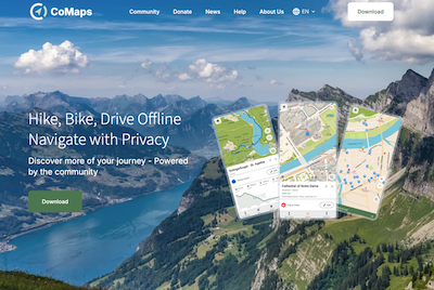
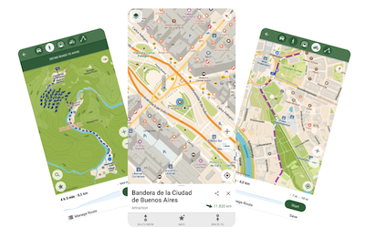
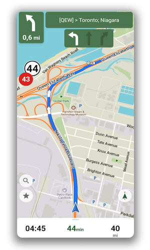
CoMaps is a free & open-source map/navigation app (mainly) for Android and iOS, that is based on OpenStreetMap data and focuses on a privacy-respecting, offline-map use. Users can download the map areas they need to their phone and then navigate those maps fully offline. In addition to OSM data, the app also includes offline Wikipedia-articles to points of interest that have those links saved in OSM.
CoMaps started in May 2025 as a fork of Organic Maps, which itself is a fork of maps.me, made by a group of volunteer contributors to Organic Maps. There are a couple of reasons for CoMaps forking from Organic Maps, centered around open source, transparency and shared decision making. These concerns were brought to the leadership of the company behind Organic Maps in an open letter. Given the lack of response and meaningful changes, CoMaps was been started to create a more open and community-governed project.
Since then, CoMaps has been progressing quite rapidly for a “new” project: In 2025 we made 12 releases and started implementing our own improvements. This includes updated map styles, an improved routing engine, increasing details shown for electric vehicle chargers, and the ability to use your own map server, to be less dependent on CoMaps infrastructure.
Outside the technology bits, we have also grown our community quite a lot. Both in terms of code contributors but also all the folks that volunteer their time for making translations, writing blog & social media posts, running language-specific community chats and many more.
3. Are the users of CoMaps typically already familiar with OpenStreetMap?
CoMaps is used by many different types of users, with different levels of familiarity with OpenStreetMap. Some of our most active users, and of course also contributors, are very familiar with OpenStreetMap and started using or contributing to CoMaps coming from the larger OSM world.
But there will be also many users who aren’t yet familiar with what OSM is and how to contribute to it. These are people who found CoMaps by way of a recommendation from their friends or family, or read about the project online when looking for map/navigation apps. As more and more people try to “degoogle” their lives, want to avoid “big tech” and lower their reliance on tools controlled by US corporations, the group of users who aren’t yet familiar with OSM but that just look for a replacement to commercial maps is likely to increase. Offline map apps are also really popular with backpackers and people with poor cell reception.
As time goes on, some users slowly “graduate” from being a pure consumer of OSM to becoming active contributors to OSM. This can start with using the basic OSM editor that’s part of CoMaps to make simple additions or leave notes, before moving to more dedicated and advanced editors. Bastian’s story of how he got into OpenStreetMap is a good example of that: His first contact to OSM was through using Organic Maps, which led him down the rabbit hole.
4. To what extent is the goal of the service “just” to provide a useful tool for navigation versus trying to bring users into the OpenStreetMap community and encouraging them to contribute?
We do see CoMaps as an important pathway for people to enter the OSM community with a low entry barrier, both through technical and social means.
On the technical level, we aim to keep the OSM editor inside CoMaps comparatively simple. It is focused on adding/editing simple Points of Interests and objects, without needing to know or understand the keys & tags of OSM. For more complex or potentially destructive edits (like removing objects), we allow users to submit notes to OSM instead, to avoid that well-meaning newcomers accidentally delete information. The submitting of notes instead of edits works even for users who don’t have an OSM account yet, as they will be submitted as anonymous notes. By keeping things simple, we aim to get people interested in contributing, to help them onboard to become more regular OSM contributors down the line. We also think a lot about how to communicate and “onboard” the concept that edits will be sent out to the world, and the map is made accurate through their contributions.
To help with this onboarding, we have the community of CoMaps: Contributing and editing OSM are frequent topics on our community channels, whether that’s in the Matrix chat rooms or on Mastodon, Reddit etc. People share their questions and advice on how to improve the data in OSM, and through this learn to contribute also outside of CoMaps.
We also try to facilitate this by sharing tips and suggestions on how to contribute to OSM on our project website, e.g. how to spot common tagging mistakes like typos that can help improve routing, or how to help by responding to notes left by other CoMaps users.
Through these different pathways of engaging with OSM through CoMaps and its community we try to grow the OSM community as well.
5. the sheer comprehensiveness of OSM can create a major challenge in terms of visualizing the data on a map. How do you solve this?
Ultimately, there is not a single way to “solve” this challenge, as different use cases require different maps and decisions for what to display on them and how. While this can be a challenge, it is also the big strength of OSM, as it enables creating maps tailored to those different use cases: Whether that’s bike navigation via BRouter, “vampire routing” to stay in the shade or plotting waterways.
For CoMaps we strive to create simple and readable maps that deliver a great experience for the most common “general purpose” map use cases, instead of diving deep into some or all of the potential specialist use cases. That means we prioritise creating maps that are very readable for general foot/bike/car navigation and exploration, displaying relevant POIs and objects, without cluttering the map with the full level of detail that OSM would theoretically afford.
The reasoning for this is that there is an inherent trade-off that generalist apps face. This is between simplicity or ease-of-use and how customizable/adaptable to specialist use cases your app can be. As you add more configuration or display options, your app becomes more and more able to support comparetively rare use-cases, but this comes at the cost at becoming much harder to understand due to this wealth of configuration options, which even affect the more common use cases.
Which isn’t to say that one approach is better than the other, as there are many specialist/niche use cases for maps for which other apps might be better suited than CoMaps is. Luckily, in the digital commons space around OSM & open source, we do not need to compete or be “the best app for everything”, instead we are happy if we can provide an app that works for most people and their most common map needs, and encourage people to use other free & open tools for the times where CoMaps isn’t ideal. We also happily work with those who do want a niche app, like BlueLight Maps which is a forked app for emergency vehicles and has contributed back to the project.
6. What is the best way for people to get involved in the CoMaps project?
There are many ways to get involved with CoMaps, as there’s always a lot of things to do. It’s important to note that writing code for the apps, while very important, is only one aspect of contributing. We can always need help with many non-code tasks too: Whether that’s writing documentation/help pages; making translations to other languages; creating graphics for the app or website; responding to support requests or inquiries on social media; or any other task, help is always welcome.
For people who want to get to know us better, the easiest entry point is probably our main Matrix room (which is also bridged to Telegram). But really any of our online chat groups can be a good entry point: www.comaps.app/community/

7. Last year OpenStreetMap celebrated 20 years. Where do you think the project will be in another 20 years?
It’s so hard to predict! Hopefully, much like the web and wikis, user-contributed data and apps will become even more common, and *“giving back”* will be more of an obvious choice. Google relies heavily on user submissions and edits with their maps, and many folks now have been raised on entertainment like Minecraft and Roblox where user-made content is not just key but even somewhat prestigious.
There’s also the aforementioned trend towards divesting from big tech, focusing more on privacy, and “degoogling” ones life. So the idea that you’re not being taken advantage of by a closed for-profit corporation is seeing some progress too! Which is all to say, hopefully both OSM and CoMaps will endure and even grow as public resources, unable to be walled off for private profit.
Thank you, CoMaps team! It is so important to move OpenStreetMap from niche, hobbyist community to tool used broadly (and thus also supported and maintained) by society. Services like CoMaps are such an important entry point for getting people into the community.
Keep up the good work, and I look forward to following your progress.
Please let us know if your community would like to be part of our interview series here on our blog. If you are or know of someone we should interview, please get in touch, we’re always looking to promote people doing interesting things with open geo data.