Hi everyone,
welcome to the July 2024 edition of #fridaygeotrivia, our a social media geotrivia contest. We play on the final Friday of every month.
The game will be played on Friday, 26th of July, at 17:00 Berlin time, 4pm London time, 11am New York time.
See how to play below.
The July 2024 geotrivia question:
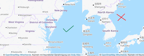
Naming places is always hard, and so we often name places after other places. Unfortunately this can also often lead to confusion.
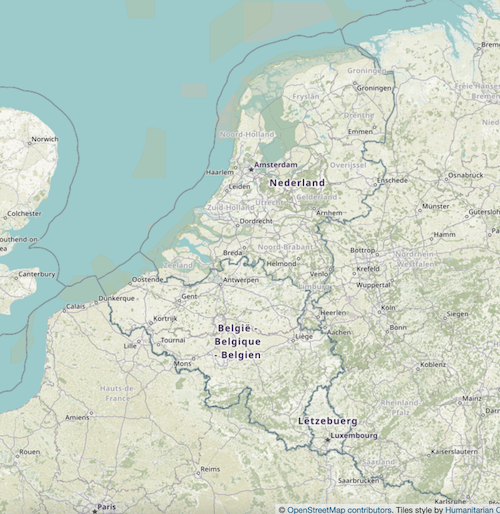
Your task today is to find sets of places - countries or admin level 2 (states/provinces) - such that one name is uniquely a geographically modified version of the other.
An example: we would award a point for West Virginia and Virginia because there is no “East Virginia” or “North Virginia”. But no points for North Korea because there is also a South Korea.
As always:
-
Only one answer per toot
-
You must include the hashtag #fridaygeotrivia and the emoji flag of relevant countries
-
The places must be countries or admin level 2 (states/provinces). Not cities.
Prizes
#fridaygeotrivia is a game with two prizes:
-
the sheer joy of geographic knowledge and pedantry.
-
the bragging rights of getting the answer first.
The #fridaygeotrivia Mastodon thread:
The winner
The prize went to @antonia, with second place claimed by Andy Allan
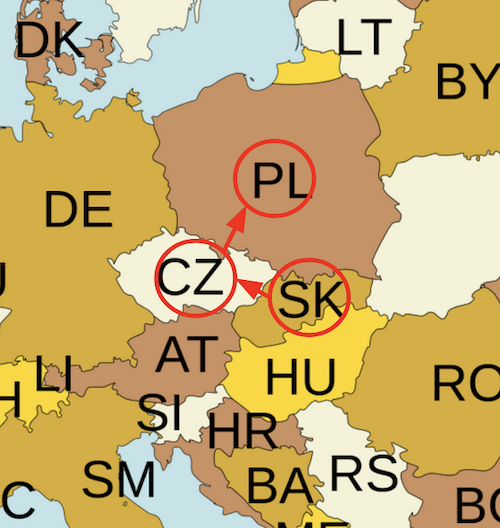
This month’s geotrivia answer:
How to play
Anyone can join in, you just need a Mastodon account.
-
Follow us on Mastodon, our account is @opencage@en.osm.town
-
When the game starts we will post the question here on the blog and on Mastodon, and will embed the Mastodon question here. We highly recommend using a mastodon client you feel comfortable with. We’ve made the switch to the Elk client and are loving it, but use whatever works for you.
-
Reply to the question thread on Mastodon (it will be embedded above) using the hashtag #fridaygeotrivia in your answer.
-
Only one answer per response (don’t stuff multiple answers into a single reply).
-
Our definition of “country” is usually (it depends on the question) any place with an ISO 3166-1 alpha-2 code. Read more background about ISO and country codes in our guide.
-
To get full points for an answer it is good form not just to name the relevant country but (if possible) to include the emoji flags of the country.
-
While you can use a map, please do NOT use the internet to just search for an answer. That is cheating and will lead to seriously bad geokarma.
Some people have complained that the format is a bit chaotic and hard to follow. Yes. The mad chaos is part of the fun. Embrace it. The goal is just to have fun and learn. We win by playing
Thanks for playing,
]]>