Hi everyone,
today’s post is to announce a slight change in geocoder behaviour,
specifically for the case of reverse geocoding to roads or streets without
names. From today whenever we geocode to a road without a name we will
return set a name of “unnamed road”.
You might ask why a road would not have a name. There are a few possible reasons:
-
First up, the road may be very new and not yet named.
-
The road may be very small and thus unnamed, imagine a dirt road on a field or similar.
-
The road may be part of an informal settlement with no official names.
-
Finally, the road may have a name, but the name is just not yet in the datasources we rely upon, most notably OpenStreetMap. In that case someone with local knowledge can add the name and our geocoding API will have it within 48 hours.
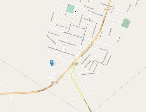
Here’s a screenshot taken from openstreetmap.org (© OpenStreetMap contributors) showing a community in Brazil where new roads have been built but not yet named.

A request for the coordinates -22.8736,-51.3963 (the location of the map
pin shown) will now return:
    ...
    "components" : {
      "ISO_3166-1_alpha-2" : "BR",
      "ISO_3166-1_alpha-3" : "BRA",
      "ISO_3166-2" : [
        "BR-PR"
      ],
      "_category" : "road",
      "_normalized_city" : "Florestópolis"
      "_type" : "road",
      "continent" : "South America",
      "country" : "Brazil",
      "country_code" : "br",
      "municipality": "Região Geográfica Imediata de Londrina",
      "region": "South Region",
      "road" : "unnamed road",
      "road_type" : "residential",
      "state": "Paraná",
      "state_code" : "PR",
      "state_district" : "Região Geográfica Intermediária de Londrina",
      "town" : "Florestópolis"
    },
    ...
    "formatted" : "unnamed road, Florestópolis - PR, Brazil",
You can find all the details of road matching (enabled via the optional API
parameter roadinfo
in the relevant section of our API documentation.
We’ve noted this change in our public Change Log. If you are using our API we strongly encourage you to “watch” the Change Log on GitHub. Changes are very rare, but it’s best to be aware of them.
Many thanks to the customer who made us aware of the need for this improvement. If you have suggestions of how we could improve the geocoding API please get in touch.
Happy geocoding,