In the February 2025 edition of our interview series with OpenStreetMap communities around the world, we speak with open source geospatial software and OpenStreetMap veteran Just van den Broecke about the OpenStreetMap Alpumapa Workshop.
1. Who are you and what do you do? What got you into OpenStreetMap?
Just van den Broecke from The Netherlands, a long-time open source geospatial professional. I wrangle geospatial data, a.k.a. ETL, work on geospatial web services like OGC REST APIs, and make maps like map5topo.nl, a topographic map of The Netherlands.
Registered my OSM account ‘justb’ in 2005. Was then mapping inline skate-routes and contributed to hiking for years. Though I was not a very active mapper, I recently revived, also through this project and joining OSM-ES.
2. What is “Mapas y Tapas” in Alpujarra and why did you create it? Who participates?
“Mapas y Tapas” is a free Spanish translation of “Mapping Party”. We are a group, now mainly around Ugíjar, that started from a few workshops. The idea is getting together in any Alpujarra village bar, go out mapping, the “Mapas”. Then reconvene at the bar, discussing results with drinks and “Tapas” (free with every drink in Andalusia).
Why? Several reasons: the Alpujarra or “Las Alpujarras”, a hidden gem in Spain!, is sparsely mapped in OpenStreetMap. Municipalities are attracting digital nomads as one way to counter depopulation. For this, Alpujarra Knowmads was established. Then at least the area needs to be mapped, in particular amenities (bars, shops, opening times…) . Also the well-known commercial map providers have sparse and outdated maps. Another reason is that just after I joined OSM-ES (Telegram) in oct 2024, the DANA storm in Valencia broke out. It appeared that most of the small villages, “pueblos”, around Valencia were poorly mapped, hindering navigation for aid workers. Quickly the OSM-ES community established a HOT project where 100s of mappers worldwide mapped the areas the best they could. DANA hit Málaga and mostly Valencia, the Alpujarra is in between, was lucky this time…And more recently: OSM is a perfect alternative for “Big Tech” maps. I try to convince folks, also non-mappers, to use OSM-based apps like Organic Maps.
Basically anyone participates, young & old, both local Spanish and what we could call immigrants or expats, mostly from Northern Europe, like UK, Denmark, The Netherlands.
3. What are the unique challenges and pleasures of mapping in this region of Spain? What aspects of the projects should the rest of the world be aware of?
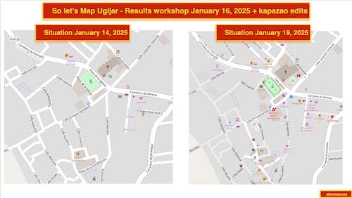
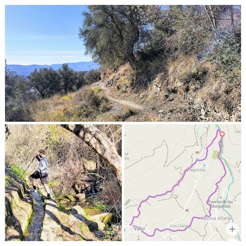
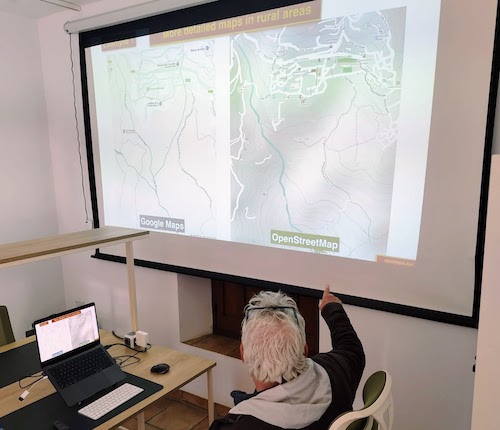
There are many pleasures first: being outdoor in magnificent landscapes and lovely, mostly former Moorish, whitewashed villages. Also the fact that there is so much to map makes, let’s say mapping amenities with EveryDoor, you feel accomplishing a lot. I showed before/after maps and results are staggering. Also we have some remote Spanish “armchair mappers” helping out. Also the support from the Spanish OSM community is warm.
Challenges? Well, speaking a bit of Spanish helps. Also convincing older local people. Some areas are really remote, hard to drive with regular cars. And off course: beware of getting burnt from the sun! And please: use the Buildings and Addresses Import Spain procedures to import, i.s.o. drawing buildings on aerial imagery, however tempting. Spanish Cadastre provides open (INSPIRE) data!
The greatest challenge is marketing and communication: how/where to announce, how to keep in touch. Within the region Facebook and Instagram are still a major communication channel for villages. Challenge is also to explain what OSM is about, why it matters for the region. Communication is also often with leaflets and cars with speakers driving around.
4. What have you learned? What is the best way for people to do something similar in their region?
Start super-simple: only with the EveryDoor app. Maybe StreetComplete, though Android-only. Leave Id, JOSM etc for much later. Advantage is: no need to bring a laptop. Also let them install Organic Maps (OM) and do some navigation, share a GPX file and hike together. Record the track with OM.
Also hold regular meetups, maybe once a week, on a fixed time/place, it is very hard to remain momentum. There are many distractions here as the area is also well-known for its informal social networks and every week there is some “fiesta”. But to be honest, “distractions”, is not the right word: the local communities of both Spanish and non-Spanish blend well together, giving experience to a warm and richer social life than many of the big cities and coastal towns.
5. What steps could the global OpenStreetMap community take to help support local mapping like this?
Somehow to have a platform where smaller groups can gather, and where announcements can be made. The OSM-ES Telegram (OSM Forum is hardly used in Spain) group is very welcoming but overwhelming in messages in a single thread, especially to newcomers.
6. Last year OpenStreetMap celebrated 20 years. As someone who has been very active in OSM in many ways for a long time, where do you think the project will be in another 20 years?
That is a very tough question. What we now see is the advance of AI, often uncontrolled. For good and bad this will influence the way we will be mapping. Also the expanding effect of Overture Maps may be beneficial for OSM, but at the same time we need to hold on that OSM remains the central source/project. The last few months, at least within The Netherlands, there is an enormous movement to “Big Tech Alternatives”, like X to Mastodon etc. In this OSM is always touted as the alternative for the well-known proprietary providers with apps like Organic Maps, OSMAnd, MagicEarth. If folks figure out: “hey I can add stuff myself”, that may increase the number of mappers. At the same time, we already experience this in Open Source GitHub repos, often AI-driven “vandalism” should be guarded for. But overall, if the OSM Community sticks together, I foresee a bright future ahead!
Thank you, Just! Great work with the mapping and with the community building. Stay up to date on the project and Just by following him on Mastodon, or of course on the Alpumapa site.
Happy mapping,
Please let us know if your community would like to be part of our interview series here on our blog. If you are or know of someone we should interview, please get in touch, we’re always looking to promote people doing interesting things with open geo data.