We keep the momentum going on our OpenStreetMap interview series, this time chatting with Dustin Carlino about his recently launched business A/B Street, which, like OpenCage, heavily relies on OpenStreetMap. A/B Street is a consultancy building open source transportation planning tools.
1. Who are you and what do you do? What got you into OpenStreetMap?
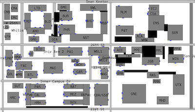
I’ve been writing software for fun most of my life, and a love of videogames and level design meant that maps were inevitable. My first project as a first-year in university was walking around campus, pretending I knew how to survey, and hand-drawing a map that showed people how to cut through air-conditioned buildings to avoid the Texas heat.
Right after that project, I found OpenStreetMap and felt so silly. But then I realized what OSM would let me do. I grew up in a car-dominated suburbia, so at the time I believed autonomous vehicles would fix many problems. I built a traffic simulator using OSM data to study bizarre (now I realize dystopian) futures where people could run micro-auctions to change a red light to green faster, for example.
I then moved to Seattle and gradually experienced the joy of living in places with denser land use, public transit, a cycling network, and people who walk almost anywhere. My life mission is to transform cities into places where driving isn’t a lifestyle most people are forced into. The sheer breadth and depth of detail in OSM and the incredibly passionate people involved with it have made this dream possible at all.
(If you’re still curious, find more here)
2. What is A/B Street? What prompted you to start the company? Who are the customers?
A/B Street has become three things by this point. It started in 2018 as a blend between a computer game and a seriously detailed agent-based traffic simulator. Anybody could pull down OSM data, edit lanes on a road, and watch precise effects on individual drivers, cyclists, and pedestrians. Like A/B testing in marketing, the goal was to encourage rapid “optioneering”, and give the general public better ways of understanding proposals affecting where they live.
The traffic sim idea was too grand, though. In 2020 after alpha launch, it morphed into more targeted projects to study 15-minute neighborhoods and design low-traffic neighborhoods, all under the same A/B Street umbrella. I moved to London and finally found my audience. Bristol City Council enthusiastically used my tool for a liveable neighbourhood consultation, and I experienced my dream at live design sessions as residents collaborated with local government to design something that has now been physically built!
At the beginning of 2025, it was clear I needed to formally start my consultancy A/B Street Ltd. So far I’ve worked with Sustrans on two tools for Scottish local authorities to design strategic cycle networks and connected neighbourhoods. I’ve also done some frontend and GIS consulting for an exciting startup in the urban planning space.
Through the years, I’ve worked with a mix of local and national government, private industry, and campaign groups on open source and proprietary projects. If you want to improve the world around you using the power of OSM, then get in touch!
3. What are the unique challenges around using OpenStreetMap data for planning purposes?
Inconsistent data looks visually distracting when rendered, but when used for any kind of analysis, it’s an even bigger problem. I’m developing a new service to understand the walkability of cities in depth – where are narrow or missing pavements and a lack of crossings over big roads causing the most problems for people who could otherwise have a short walk to school or shops? Sidewalks in OSM are mapped either as separately drawn footways or as a tag on the road. Often these styles are mixed, and when mappers switch to separate sidewalks, they don’t always update the tags on the road.
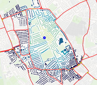
Crossings over big roads are one of the key elements in this app, but they’re practically invisible in most renderers, so they’re easy to forget. The isochrone below shows how easily somebody can cross the main roads on most sides, but missing crossings on one side suddenly cut things off.
Besides making it much faster and easier to fix bad data directly in this app, my approach is currently to transform both directions between the two sidewalk representations, since each one is useful in different situations. This is really tough to do automate in every case, but through the process I’m building up a very rigorous test suite!
4. What steps could the OpenStreetMap community take to improve the data for planning purposes?
You can’t correct data that you can’t see. When I was starting A/B Street in Seattle, so many of my ideas involved repurposing street parking, but there was almost no data on it, because only one tool really showed it. So from the start, I wanted to render the OSM lane tagging to help fix lane data. osm2streets is the result of this, and I’m also very excited by osmpie, a new project taking this much further.
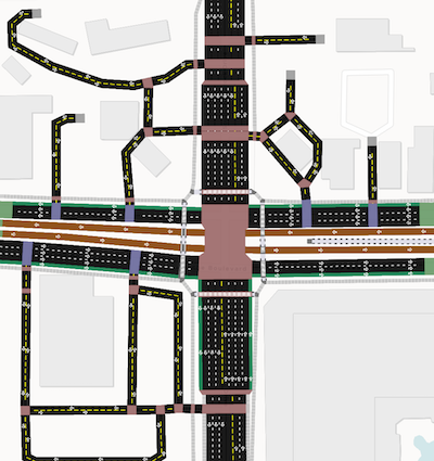
The community needs more specialized maps focused on something like sidewalks and crossings, and showing consequences of the map data really easily. Imagine you find an unusual route, you spot a mis-tagged crossing possibly causing the issue, and you can check that the router behaves as expected before you upload your changeset. A tight feedback loop makes it so much easier to fix data, not waiting weeks for a downstream app to pull in your changes. The tech stack behind A/B Street projects makes this possible, running any sort of analysis directly in your web browser. The same thing unlocks the planning capabilities. You could simulate adding a new crossing to a big road or a totally new bridge over a river, immediately see the effects on a route, and even model how many people might take advantage of the new infrastructure – in seconds.
5. Last year OpenStreetMap celebrated 20 years. As someone who has been active in OSM for years, where do you think the project will be in another 20 years?
I can barely imagine what software development, the urban environment, or the world in general will be like in 20 years! I’d love to see OSM become the authoritative data source for local governments, and for more targeted editors/tooling to bring more mappers in. I can imagine LIDAR and computer vision improvements will mean more semi-automated imports and micromapping, and that will drive richer tagging schemas to better represent the complexities of urban streetscapes. I really hope cities in the next 20 years will rapidly adapt to more sustainable transportation and land use and that OSM will not only keep up with these changes, but empower them to be done with more transparency, community involvement, and strategy.
Thank you, Dustin! And good luck with A/B Street. It is great to see yes another example of the innovation made possible by OpenStreetMap.
Anyone interest in learning more should come along to Geomob London on Oct 22nd, 2025, where Dustin will be among the speakers.
Happy mapping (of streets and everything else!),
Please let us know if your community would like to be part of our interview series here on our blog. If you are or know of someone we should interview, please get in touch, we’re always looking to promote people doing interesting things with open geo data.