Today we resume our long-running interview series with OpenStreetMap communities around the world by speakng with Letwin Pondo and Ruvimbo Supiya, two representatives of the OpenStreetMap community in Zimbabwe.
1. Who are you and what do you do? What got you into OpenStreetMap?
I am Letwin Pondo, a passionate OSM Contributor from Zimbabwe, OSM Zimbabwe Steering Committee, YouthMapper and founder of Ladies in Maps Zimbabwe. So I got to know about OSM in November of 2021 through social media, then found other OSM contributors in the country, registered YouthMappers Chapter and now I was aware of what it actually is. I spend most of my time working on tasks, working with the community or organizing events for Open Source Communities and the Humanitarian OpenStreetMap Team.
I am Ruvimbo Supiya, OSM Zimbabwe steering committee member, YouthMapper. I am passionate about drone technology, geospatial and space technologies. My passion for geospatial technology is what got me contributing on OpenStreetMap. My first contribution was in January 2022 when OSM Zimbabwe hosted the Africa Monthly Mapathon. I spend most of my time on OSM creating and managing tasks for OSM Zimbabwe, teaching others on how to contribute quality data and volunteering for STEM initiatives.
2. What would you say is the current state of OSM and the OSM community in Zimbabwe?
Letwin: Currently we are operating as an unregistered non-profit organization though working on the registration process. I’d say we have a very large community but with a few actually committing to the cause. The wings of OSM Zimbabwe cover all our YouthMapper Chapters, Ladies in Maps and some individual contributors. Most of our towns and cities are mapped and most remote areas unmapped.
Ruvimbo: OSM Zimbabwe is a community of passionate individuals which I believe can grow with more motivation and commitment. The steering committee is working towards registering the organization to open more mapping opportunities. Zimbabwe needs more mapping to fill the data gap for development which means need for more contributors.
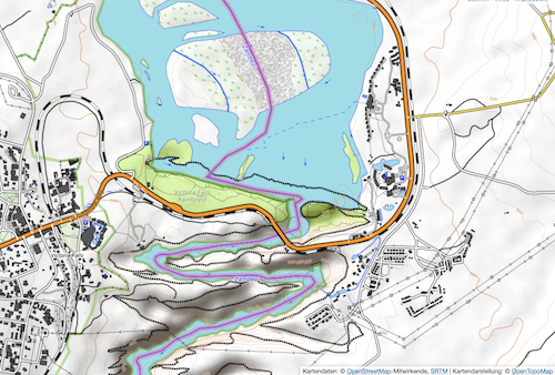
Screenshot of the famous Victoria Falls on the border between Zimbabwe and Zambia - as mapped in OpenTopoMap
3. What are the unique challenges and pleasures of OpenStreetMap in Zimbabwe? What things should the rest of the world be aware of?
Letwin: Our greatest challenge is funding. There are a lot of activities that need open data intervention in Zimbabwe but it would need some funding for the community to take up those. Our other challenge is commitment - the majority of the contributors or community members at some point lose interest in the community and its activities leaving the greater majority being YouthMappers. Pleasures are that we have a diverse community that is represented by most of the various groups and age groups in the country.
Ruvimbo: Pleasures of OSM Zimbabwe are being part of a global community that is pushing towards a common goal and support offered by each community member in geospatial sense. A major challenge is funding and again operating as an unregistered organization is a major set back.
4. What is the best way to get involved? Is there a regular meet-up? A mailing list? Where does the community meet (in person and online)?
Letwin: Tthe community has a WhatsApp group that is used as a medium for communication. Most of our events are in person though not regular.
Ruvimbo: OSM Zimbabwe meets in person and online. Though there is a need for more in person events to keep the community going.
5. What steps could the global OpenStreetMap community take to help support OSM in Zimbabwe and southern Africa in general?
Letwin: Funding projects, providing OSM swag packs or stickers for motivation and helping in publicity, support and troubleshooting when communities go silent. Usually communities collapse not because they have nothing to do but when they lack the drive or motivation, they crash.
Ruvimbo: Other OSM communities that are well established can offer sort of mentorship to communities that are working towards establishment.
6. Our standard closing question: OpenStreetMap will soon celebrate its 20th birthday, so we are well into the “teenager” stage of the project. But what will it look likes when it “grows up”? Where do you think the project will be in 10 years time, both globally, in Zimbabwe specifically?
Letwin: OSM is really advancing and moving forward, and what I have realized is whether you want to map your area or not, with OpenStreetMap that area will always be mapped even by someone miles away. So this gives the confidence that the project will provide much more quality and valuable data for the whole world.
Ruvimbo: OpenStreetMap is the “in thing”. I think in the next ten years it will be a strong powerhouse for open geospatial data and technology. As for OSM Zimbabwe I also think with the effort each and every individual is putting in the community it will provide Zimbabwe with every geospatial data need. OSM Zimbabwe is for every Zimbabwean.
Thank you very much Letwin and Ruvimbo, for taking the time to speak with us, and for your efforts in building the OSM community in Zimbabwe. Long may it thrive!
Happy mapping,
Please let us know if your community would like to be part of our interview series here on our blog. If you are or know of someone we should interview, please get in touch, we’re always looking to promote people doing interesting things with open geo data.