Hi everyone,
I am pleased to announce that our new service OpenCage Geosearch is now live!
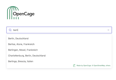
So what exactly is geosearch, and how is it different than geocoding?
Geocoding (forward geocoding to be precise) is the process of turning an address or placename into geographic coordinates. Geosearch is a tool to turn text into place names (which can then be used as an input into geocoding). The most obvious example is in a search form, when someone types “Ber” you want to show the user “Berlin, Germany”, so that they can more easily select the correct location. We explain all this in more detail in our guide to the differences between geocoding and geosearch.
A few geosearch product highlights:
-
A drop in solution you can have set up in a few minutes.
-
Global coverage of “places”. Our search as countries, states, regions, cities, towns, villages, neighbourhoods, and major POIs. We don’t have full addresses or postcodes. We may add those later.
-
Easily configurable to show results in different languages (English by default, but we also support French, German, and Spanish), to change the number of results shows, or to limit results to a specific country or bounding box. See the full documentation.
-
The javascript SDK is fully open source and builds on top of the solid base of Algolia’s excellent Autocomplete library. Thank you, Algolia!
-
and coming very soon: Leaflet and OpenLayers plugins for those of you who want to embed the search on maps,
We were excited to get this out and start learning from users, so we haven’t yet built a full self-service purchase process. We will get there. But to make up for it, in the meanwhile we are offering introductory discounted pricing for geosearch.
Many thanks to all of you who signed up for the geosearch early access list, and helped us with the alpha testing. We learned a lot.
If you would like to make it easier for your users to search for locations, be it in a search form or a map, please give OpenCage Geosearch a look.
Happy geosearching,