Hi everyone,
one of the great annoyances of working with geospatial data is that there is no clear agreement as to how geographic coordinates should be represented. Some tools expect longitude, latitude format, others expect the opposite. Some tools wanted named parameters, though there is also variance in whether or how the names should be abbreviated (is it lon or lng?). The situation is maddening. Converting between the various formats is tedious and error prone. It is the pebble in the shoe that makes a pleasant walk agonizing.
Tom MacWright has written a great overview of which services use which format. He summarizes:
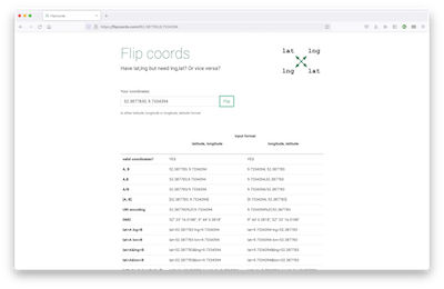
So, what to do? Unfortunately we can’t magically change the input tools and services we depend on are expecting. But we can at least make the it easier to flip between those formats. Internally we’ve built a little tool that takes a pair of numbers and spits out various formats. For the benefit of everyone we’ve now put that logic on it’s own site: introducing FlipCoords.
The idea is simple: you enter two numbers, hit “flip”, and we then render all useful formats for those numbers assuming they are both latitude, longitude OR longitude, latitude. You can then quickly copy the format you need.
Since the tool went live last week we’ve had some great feedback leading to a few additional formats and improvements. Please try it out and send us your feedback. If you find FlipCoords useful please share it with your geospatial friends.
Happy coordinate flipping,