Hi everyone,
welcome to the May 2021 #fridaygeotrivia!
As is our tradition, on the final Friday of month on twitter under the hashtag #fridaygeotrivia we run a geotrivia contest. Afterwards we post the answers here on the blog.
See below for how to play.
The May 2021 geotrivia question:
“Name pairs of countries that share land borders interrupted by other countries.”
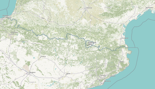
An example: Spain (ES) and France (FR) border each other, but that border is interrupted by Andorra (AD)
Please note we are NOT looking for countries with multiple land borders, but interrupted by water. For example the United States (US) and Canada (CA) have many non-contigious land borders, but those borders are interrupted by water NOT other countries.
Prizes
#fridaygeotrivia is a game with two prizes:
-
the sheer joy of geographic knowledge and pedantry.
-
the bragging rights of getting the answer first.
Ok, time for this month's #fridaygeotrivia This month's question: Name pairs of countries that share a land border that is interrupted by other countries. Example: Spain 🇪🇸 and France 🇫🇷 share a border that is "interrupted" by Andorra 🇦🇩 pic.twitter.com/ulGRvT48eO
— OpenCage Geocoder 👉🌍 (@OpenCage) May 28, 2021
The geotrivia answer:
- Spain (ES) and France (FR) have a border "interrupted" by Andorra (AD)
- China (CN) and Russia (RU), interrupted by Mongolia (MN)
- Austria (AT) and Switzerland (CH), interrupted by Liechtenstein (LI)
- South Africa (ZA) and Mozambique (MZ), interrupted by Eswatini (SZ)
- Ukraine (UA) and Romania (RO), interrupted by Moldova (MD)
- Iran (IR) and Azerbaijan (AZ), interrupted by Armenia (AM)
- China (CN) and India (IN), who share a border twice interrupted, once by Nepal (NP) and once by Bhutan (BT)
- Jordan (JO) and Israel (IL) interrupted by Palestine (PS)
- Morocco (MA) and Western Sahara (EH) interrupted by Mauritania (MR)
How to play
Anyone can join in, you just need a twitter account. Please note - these edition of the game was played long ago - these days we play on Mastodon, not twitter.
-
Reply to the question thread on twitter (previously embedded above, but twitter sadly broke embeds) using the hashtag #fridaygeotrivia in your answer.
-
Only one answer per tweet
-
While you can use a map, please do NOT use the internet to just search for an answer. That is cheating and will lead to seriously bad geokarma.
-
To get full points for an answer it is good form not just to name the relevant country but (if possible) to include the emoji flags of the country.
Some people have complained the format is a bit chaotic and hard to follow. Yes, the mad chaos is part of the fun. Embrace it. The goal is just to have fun and learn. We win by playing
See the full list of past monthly geotrivia questions and answers. All suggestions for good trivia questions gladly received!
Happy geocoding,