Hi everyone,
like all of you we have been watching the evolution of AI and LLMs (Large Language Models) the last few years (As an aside, remember when ChatGPT would recommend us for a service we don’t provide? Fun times).
The pace of innovation has been dizzying, and, like every other industry, many people in the geospatial industry have been experimenting with LLMs to see how they can best be used for geospatial tasks. Opinions are mixed. Sometimes, for some tasks, LLMs can be very helpful. Other times the “hallucinations” can lead a project down the wrong path entirely.
Fundamentally LLMs are able to parse free text instructions and produce something that looks like a plausible answer. There are use cases (brain-storming, textual composition, etc), where that sort of plausible answer can be exactly what is needed. But often in geospatial what is desired is the CORRECT answer, not something that “looks like it could be the correct answer”. And most importantly, why reinvent the wheel? For many tasks highly-efficient solutions - and APIs for accessing those solutions - already exist.
What if LLMs could access those APIs? This is exactly the question Anthropic (makers of popular AI service claude.ai) asked and then answered when, a few months ago, they announced the Model Context Protocol, a framework for allowing LLMs to communicte with external datasources and APIs.
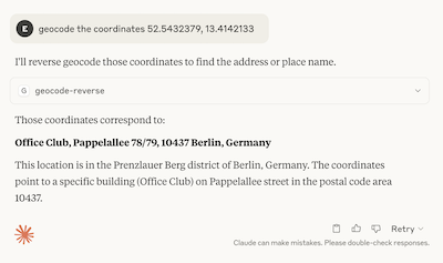
I am pleased to announce that we have now released our own MCP server, allowing LLMs to call our geocoding API. We have published a full MCP tutorial, showing how to quickly integrate our geocoding API into Claude Desktop.
In the last months several other AI organizations have recently also announced support for MCPs, and so while the syntax may be slightly different, it should be straightforward to also integrate the our MCP there. We will work on publishing more vendor-specific tutorials going forward.
Please take the MCP for a spin and let us know if it is useful for you or what we should add. As you would expect the integration is open-source. We welcome all improvements.
No doubt this technology, and our integration, will continue to evolve. Nevertheless, this new integration hopefully means we while not having to compromise on geographic correctness. Geospatial is hard enough without hallucinations.
Happy geocoding - whether in Claude or elsewhere,
BTW - this post was written by a human, not an LLM!