Friends,
As you may well know, one of
the optional parameters you can
use to call our API is called bounds, which is specified as two coordinates
points in minimum longitude, minimum latitude, maximum longitude, maximum
latitude format. Setting this parameter restricts the possible result set to
only results within that bounding box.
For example if you know you want only results in the
Balearic Islands you might
add bounds=1.07666,38.03079,5.05371,40.81381 to your requests.
But we noticed occasionally people have difficulty correctly forming their bounds queries, and of course it is easy to mix up latitude and longitude, no matter how diligent you are.
With this in mind I’m happy to report we have created a new
helper page that makes it simple to visualize bounds values.
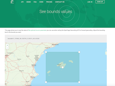
Just drag and resize the box to the exact area you want and the correct value
for the bounds parameter is displayed for you. The page is linked from the
documentation where we explain the optional bounds parameter.
I close by hoping that, while your queries should be well bounded, your imagination and potential never are.
Happy geocoding,