Hi everyone,
we’ve made a change to the
roadinfo annotation returned by our geocoding API. We now additionally try to set the fields
maxheight, maxweight, and maxwidth.
As an example here’s map showing a bridge at the coordinates 53.63086, -1.80068
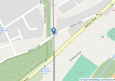
An API request to those coordinates with the optional parameter roadinfo=1 set will now return
    "roadinfo": {
        "drive_on": "left",
        "maxweight": 3.0,
        "road": "Hanson Lane",
        "road_type": "residential",
        "speed_in": "mph"
    }
thus we see that that bridge has a maximum weight of 3 metric tons.
As you would expect the various fields and their possible values are explained in the API docs.
As always the key caveat with our road information is that this information comes from crowdsourced data sources like OpenStreetMap. It is not in any way “official” or “governmental” data. It may be wrong, incomplete, or out of date. Always drive safely.
Happy geocoding,