We continue your country profiles today by speaking with Julio Costa Zambelli from OpenStreetMap Chile.
1. Who are you and what do you do? What got you into OpenStreetMap?
My name is Julio Costa and I am a 33 years old International Business Manager. During my undergraduate years I started working with eLearning platforms and founded a consulting company in that area, after graduating and working for some companies I was offered a position in charge of the eLearning platform in an academy of the local Ministry of Defense. I have always liked maps but almost seven years ago I bought a Bluetooth GPS receiver. I didn’t knew what I was going to do with it, but I knew that I needed some cartography for it, that’s how I found OpenStreetMap and started mapping and spreading the word about it.
2. What would you say is the current state of OSM and the OSM community in Chile?
OSM is quite developed in our country. Now a days you see data for probably every town and city in the country, and in some of them you can also find buildings and addresses information. We have traced many aerodrome runways and the local aeronautic authority uses OSM for its Internet Flight Information Service. We have drawn every single internal boundary at municipal, provincial and regional level. Many people are tracing powerlines, railways, landuses, every new road, and probably other things that we don’t even imagine. Our community is still relatively small, but in the last years we have seen an increase in the number of users that stay editing after the first few editions and make a significant contribution.
3. What are the unique challenges and pleasures of OpenStreetMap in Chile? What aspects of the projects in Chile should the rest of the world be aware of?
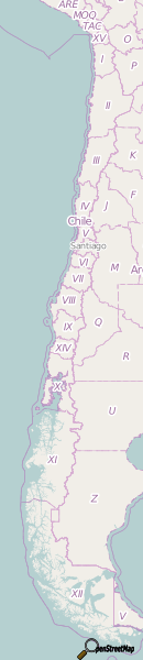
We are a +4000 kilometres long country with territories in three continents and an hyper-dismembered southern coast (in the regions of Aysen and Magallanes). The local population is relatively small (17 million people) and not evenly distributed in the territory, with 6.3 million people in Santiago and a density of one person per square kilometer in Aysen. We take pride on the quality of the data that we map and how it is way better than all the biggest local online map providers, and we appreciate all the help from mappers abroad.
4. What steps could the global OpenStreetMap community take to help support OSM in Chile? Do you think hosting SotM in Latin America in November for the first time will give the project a boost?
You can always help mapping cities and small towns all around the country, specially the smaller details like buildings, landuses, woods and waterways. Sure hosting the SotM in Latin America will give the project a boost. I hope that many people that haven’t been exposed to project will discover it. And also the people that already participate in it will be able to meet each other and coordinate our work.
5. OSM recently celebrated it’s 10th birthday, where do you think the project will be in 10 years time, both globally and in Chile specifically?
I am sure that OSM will continue this trend of turning significant websites and project into our map (Foursquare, Craigslist, Pinterest, WolframAlpha, Wikipedia, etc. were just the beginning). I hope that locally we will improve our coverage of address data, buildings and the last roads and that those improvements will bring even more volunteers and companies into our community.
Many thanks Julio, and thanks to the entire OSM Chile community. The next time I am sipping a Chilean red wine I will toast your efforts! I encourage all Spanish speaking readers to follow the OSM Chile blog. and OSMcl twitter account.
You can see all the Open Geo interviews here. If you are or know of someone we should interview, please get in touch, we’re always looking to promote people doing interesting things with open geo data.