Today we’re fortunate to speak with Jan Marsch, one of the people behind a fascinating offshoot of OpenStreetMap - OSM Buildings.
1. Who are you and what do you do? What got you into OpenStreetMap?
My name is Jan Marsch, I’m the mind and developer of OSM Buildings. Life is evenly split into family, OSM Buildings and paid contracting work and sleep.
Starting projects for Nokia Maps 2009 got my first attention to geography.Later, when 3D still wasn’t a topic I revived a few concepts and made them work with Navteq data.
It turned out I would not get any substantial support so I had too look for a different base. In 2012 I had just heard about some “volunteers map“.
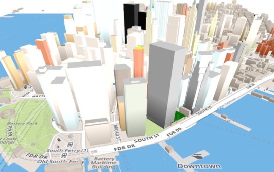
2. What is the OSM Buildings project? What is the best way for people to get involved?
OSM Buildings is best described as a tool to make cityscapes visible. The easy way, fast, beautiful. It aims on integration into other projects, for example as an additional layer to existing Leaflet maps. Ideally keep using your tools and add the extras from OSM Buildings.
There is the viewer component which can take various sources and data formats, OSM as the most prominent one.The server side provides simple access to building data, fresh updates and world wide coverage.
To get involved I’d recommend to see the examples on the website and Github and try things out yourself. Add your own GeoJSON file for immediate results.
The best way to drive the OSM Buildings forward is your ideas!
There are projects are using it as viewer for 3D charts, some are making movies with it, architects using the data for „background noise“.
I’d also love to see more code contribution, i.e. the great Inception mode from Janne Aukia.
3. What steps could the global OpenStreetMap community take to help support 3D visualization using OSM?
First and foremost, there could be a lot more tagging. Building height is most appreciated, but materials, building use, materials, colors, roof shapes etc. are all very welcome. But there is a catch: objects with a very extensive amount of details. The limits between mapping and modeling seem vanishing. The community should discuss, how it wants to handle that tendency.
4. Over the last years there seem to be more and more projects working on 3D visualization using OSM data. Are these projects competing to do the same thing or are they each going in their own direction. Can you give us an overview of the landscape? Who is doing interesting work?
OSM Buildings is not alone, but unique in its visuals and performance. There is also its 2.5D vector mode that runs on most average and below systems.
There are some specialized projects as for terrain, virtual globes or 3D Base maps.There a few clones that came up and there are also outstanding competitors like OSM2World, which seems basic but is very strong in OSM geometry processing. Mapzen’s Tangram which is very configurable and allows for great WebGL effects. Overall, we share lots of ideas. F4 Maps which is kind of a visual reference project.
Cooperation turned out to be difficult. Enthusiasts often have very distinctive ways to do things. Or OSM Buildings is seen as competition. While it is very flattering, it seems to keep the bigger projects from cooperation.
5. Last year OSM celebrated its 10th birthday. Where do you think the project will be in 10 years time?
I’m experiencing rapid commercialization around OSM. While this drives a lot of projects forward and greatly raises awareness of OSM,it also puts passion projects into competition.
OpenStreetMap is also facing automated mapping. If it aims to stay relevant, we have to adapt to that situation.
Overall, I think it will not be just one amongst 5.
Many thanks Jan. Agree with you it is hard to know if the competition between projects trying to accomplish the same task, be it 3D rendering, routing, geocoding, etc, etc is a double edged sword.
Good luck to you and everyone involved with the project. To learn more please follow @OSMBuildings.
You can see all the Open Geo interviews here. If you are or know of someone we should interview, please get in touch, we’re always looking to promote people doing interesting things with open geo data.